

Ahora estás siguiendo a
Error al seguir a usuario.
Este usuario no permite que los usuarios lo sigan.
Ya estás siguiendo a este usuario.
Tu plan de membresía solo permite 0 seguimientos. Mejora tu membresía aquí.
Dejaste de seguir correctamente a
Error al dejar de seguir al usuario.
Has recomendado exitosamente a
Error al recomendar al usuario.
Algo salió mal. Por favor, actualiza la página e intenta de nuevo.
Email verificado correctamente.

narsingdi,
bangladesh
Aquí son las 5:03 a. m.
Se unió el marzo 5, 2012
2
recomendaciones
Shariful I.
@msig0000
4,2
4,2
100%
100%
narsingdi,
bangladesh
100 %
Trabajos finalizados
100 %
Dentro del presupuesto
100 %
A tiempo
63 %
Tasa de recontratación
Geospatial Analyst,GIS,RS,Python,Spatial- Web- dev
Contacta Shariful I. sobre tu trabajo
Inicia sesión para comentar cualquier detalle por chat.
Portafolio
Portafolio
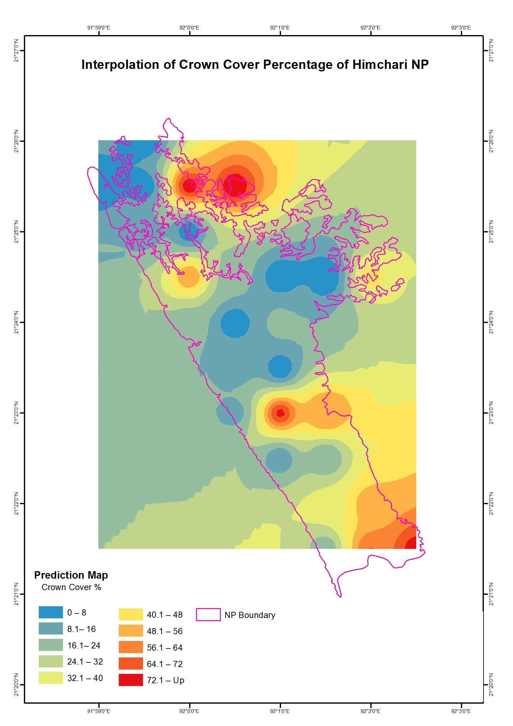

Forest density estimation from sample data


Predictive modelling
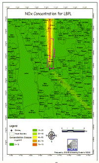

Air Dispersion Modelling(Gaussian Plane)


Using python to enrich/check database


Landuse monitoring silverlight web app


Arcgis server flex web mapping app
Forest density estimation from sample data
Predictive modelling
Air Dispersion Modelling(Gaussian Plane)
Using python to enrich/check database
Landuse monitoring silverlight web app
Arcgis server flex web mapping app
Comentarios
Cambios guardados
Mostrando 1 - 5 de 9 reseñas
$225,00 USD
Python
Cartography & Maps
Geolocation
Remote Sensing
+1 más
J

•
$166,00 USD
Python
Geospatial
•
$55,00 USD
Java
Python
Cartography & Maps
P
•
$236,00 USD
Java
Python
Cartography & Maps
P
•
$183,00 USD
Python
Cartography & Maps
Geospatial
•
Experiencia
GIS & RS Analyst
may 2013 - Presente
Here I am to oversee all GIS and RS related work. I am working as Research Officer in the GIS, RS & Modelling Division. We work with several foreign client like USAID,DFID,FAO, Weidemann,IDRC etc
GIS Analyst / Individual Contributor
ago 2012 - ene 2013 (5 meses, 1 día)
NRP is a Bangladeshi multi-disciplinary consulting firm registered under Bangladesh Joint Stock Company in 1997. nrp offers high quality consulting services in a wide spectrum of development activities and seeks to render consultancy and technical assistance services to national and international organizations, both in the public and private sectors. It offers consulting and advisory services in different areas embracing Information Management System, Land Management, Environment, Infrastructure, Education, Information Technology, Industrial Development Technology, Economic and Technical Appraisal, Monitoring & Evaluation, Human Resources Development, Research & Survey, Feasibility Studies, Sectoral and other sub-sectoral studies and others.
Project Superviser
ene 2012 - feb 2012 (1 mes, 1 día)
This project was on mapping of the community clinic in Dhaka City
In this job I had to verify ;by ArcGIS,Google Map,Google Earth;several works done by my contributors.
Educación
MSc(Geoinformatics/GIScience)
(1 año)
BSc(Geography & Environment)
(4 años)
Calificaciones
Editing in ArcGIS Desktop
ESRI Certification Course
2016
Certification URL: http://training.esri.com/campus/myOffice/mytranscript/certificate/index.cfm?c=281
Basics of Geographic Coordinate Systems
ESRI Certification Course
2016
Certification URL: http://training.esri.com/campus/myOffice/mytranscript/certificate/index.cfm?c=338
Programming for Everybody (Getting Started with Python)
Coursera Course Certificates
2016
License Number: SPA9Y2U3BDGA
Certification URL: coursera.org slash account slash accomplishments slash records slash 5N6CBBH4YF3P
Contacta Shariful I. sobre tu trabajo
Inicia sesión para comentar cualquier detalle por chat.
Verificaciones
Certificaciones
Principales habilidades
Explorar freelancers similares
Explorar galerías similares
¡Invitación enviada correctamente!
¡Gracias! Te hemos enviado un enlace para reclamar tu crédito gratuito.
Algo salió mal al enviar tu correo electrónico. Por favor, intenta de nuevo.
Falló el copiado al portapapeles. Intenta de nuevo después de ajustar tus permisos.
Copiado al portapapeles.
Cargando visualización previa
Permiso concedido para Geolocalización.
Tu sesión de acceso ha expirado y has sido desconectado. Por favor, inica sesión nuevamente.